
Writing Task 1
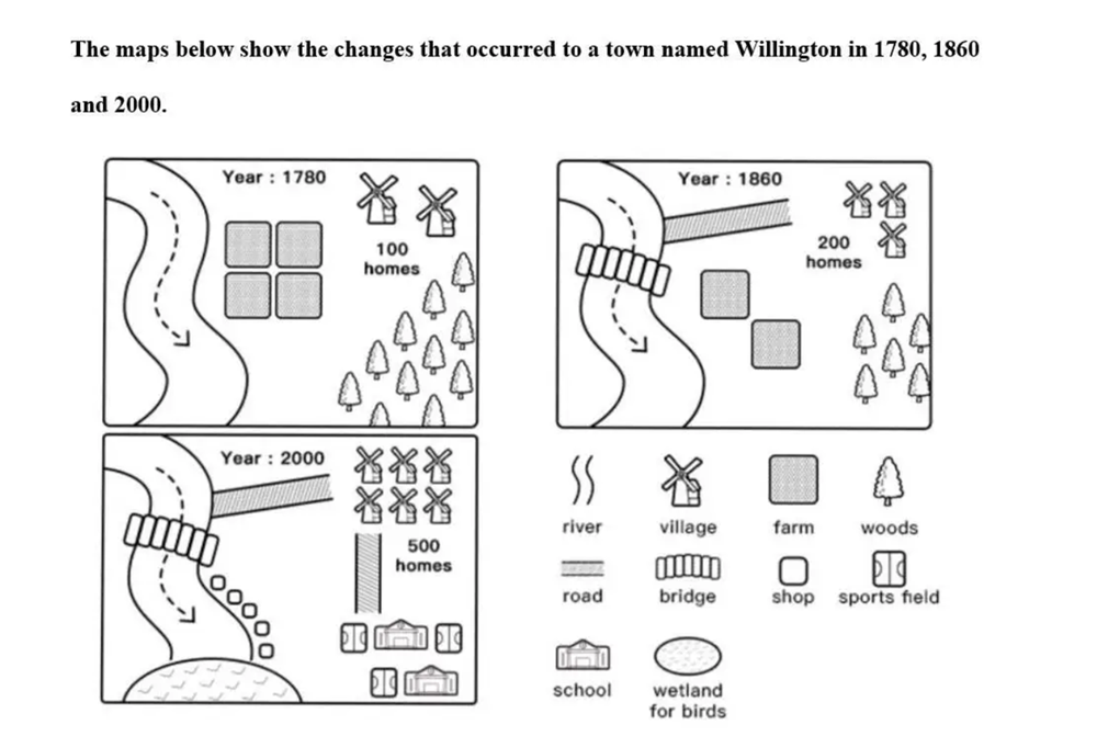
The map sketch illustrates the development of a place named Willington in 1780, 1860 and 2000. Overall, the natural features were being replaced by man-made structures over time from 1780 to 2000.
It can be seen that, between 1780 and 1860 had some noted changes with the number of farms being reduced by half during 40 years, given space to build a main road connecting the river to the residential area.Therefore, a bridge was also put up for better transportation . Moreover, the woods were also cut in half in order to double the amount of house.
From 1860 to 2000, there were no woods remaining, it was taken up by schools and sport fields, the number of houses also reached 500 and a main road between two of these places for utility. Owing to the expansion of facility and population, shops appeared alongside the river bank and wet land for birds was set up at the end of the river.
Top answer
) illustrates the development of a place named Willington in 1780, 1860 and 2000. (You changed the paragraph topic. Start a new paragraph.
- ) illustrates the development of a place named Willington in 1780, 1860 and 2000.
- (You changed the paragraph topic.
- Start a new paragraph.
- Each paragraph has a distinct topic.
- You made the same mistake as in your previous essay.
Get the Weekly English Kit 📬
New words, one handy idiom, and a 2-minute quiz — delivered to your inbox to keep your streak alive.
The map sketch (There is more than one map.) illustrates the development of a place named Willington in 1780, 1860 and 2000. (You changed the paragraph topic. Start a new paragraph. Each paragraph has a distinct topic. You made the same mistake as in your previous essay. This is not a very natural English sentence.)
 Related Questions