
The two maps below show road access to a city hospital in 2007 and 2010. Summarize the information by selecting and reporting the main features, and make comparisons where relevant.
The maps show us the changes in road constructions and some arrangements of a city hospital for 3 years (2007-2010).
It is clear fro the 2007-map that the City Hospital was located at the center, surrounded by the Ring road. The Hospital road, which intersected the city road, was the only access to the City Hospital. Along 2 sides of the road, there were bus stops and a car park for staff and residents.
In 2010, there were a few adjustments to the environs of the hospital. One striking feature is that intersections near the hospital then changed into roundabouts. The bus stops were no longer scatter along the roads; they were then merged into one big bus station on the left of the Hospital Road. In addition, the car park of the hospital then splitter into 2 portion: one was for staff remained in original location; one was opened to the public situated in the east of the City Hospital.
Overall, there were 2 major changes to the hospital: a new bus station and an additional car park.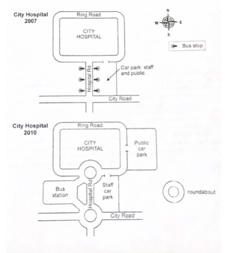
Top answer
The maps show us the changes in road constructions and some arrangements of a city hospital for 3 years (2007-2010). (Those are not good expressions. ) It is clear fro the 2007-map that the City Hospital was located at the center , (That is not a good observation.
- The maps show us the changes in road constructions and some arrangements of a city hospital for 3 years (2007-2010).
- (Those are not good expressions.
- ) It is clear fro the 2007-map that the City Hospital was located at the center , (That is not a good observation.
- All maps are designed to put the focus at the center.
- ) surrounded by the Ring r oad.
Get the Weekly English Kit 📬
New words, one handy idiom, and a 2-minute quiz — delivered to your inbox to keep your streak alive.
The maps show us the changes in road constructions and some arrangements of a city hospital for 3 years (2007-2010). (Those are not good expressions. See example paragraphs below.)
It is clear
 Related Questions