
PLS!!! Help me by checking my task 1 _ Water front area
Topic: The map below shows the changes that have taken place of the water front area of a town called Darwin between 2009 and 2014.
My task 1:
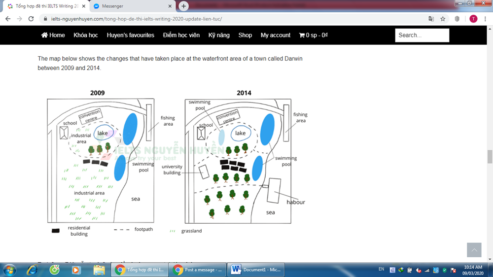
The map illustrates how the water front area located in Darwin town changes from 2009 to 2014.
Overall, it is obvious that there are some considerable changes for the water front area of Darwin town, including the construction of habour, university building and swimming pool as well as the plant of many trees.
In the northwest water front area, there were a school and a convention area, which still remain unchanged from 2009 to 2014. In 2009, there was comprised a lake, industrial area and various trees inside the footpath circle. After five years, this industrial area was demolished to make way for new swimming pool. In addition, the footpath was expanded to be linked to the west and the east area.
In 2009, the south area of water front was industrial area and some residential building. Over a period of five years, the trees were planted and a university building was built, which replaced industrial area. Moreover, the number of residential building increased twofold between 2009 and 2014. In the southeast area, a habour was constructed which connected to the west area via the footpath.
Top answer
The map illustrates how the water front area located in Darwin town changes changed from 2009 to 2014. Overall, it is obvious that there are were some considerable changes for to the water front area of Darwin town, including the construction of a habour, a university building and a swimming pool as well as the plant ing of many trees. In the northwest water front area, there were a school and a convention area, which still remain ed unchanged from 2009 to 2014.
- The map illustrates how the water front area located in Darwin town changes changed from 2009 to 2014.
- Overall, it is obvious that there are were some considerable changes for to the water front area of Darwin town, including the construction of a habour, a university building and a swimming pool as well as the plant ing of many trees.
- In the northwest water front area, there were a school and a convention area, which still remain ed unchanged from 2009 to 2014.
- In 2009, there was comprised a lake, an industrial area and various some trees inside the circular footpath in the northern part of that area.
- circle.
Get the Weekly English Kit 📬
New words, one handy idiom, and a 2-minute quiz — delivered to your inbox to keep your streak alive.
The map illustrates how the water front area located in Darwin town changes changed from 2009 to 2014.
Overall, it is obvious that there are were some considerable changes for to the water front area of Darwin town, incl
 Related Questions