
Please review my IELTS writing task 1, thanks
The map below shows the development of the village of Ryemouth between 1995 and present. Summarize the information by selecting and reporting the main features, and make comparisons where relevant.
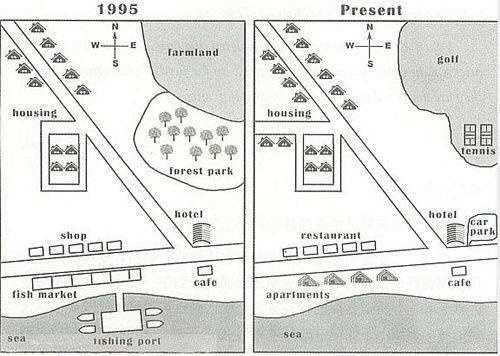
The map illustrates the transformation of the coastal village of Ryemouth between 1995 and the present. Overall, its road network and house estate have expanded, while its fishing facilities, agricultural land, and woodland have been replaced with property development and recreational amenities.
In 1995, in the northwest were apartments that lined the road running northwest to southeast. In the northeast was an expanse of farm land, adjacent to a forest park. On the shores in the south, there was a fishing port, to the north of which lay a fish market along the road running west to east, opposite to a row of shops. At the southeastern corner, a hotel and a cafe were separated by the west-east road.
Today, the housing estate extends to the southeast along the road, with a new road branching off to the west. The farm land and forest park are repurposed for entertainment use, as they give way to a golf course, which contain a tennis court in its south. The fishing port is demolished, while the fish market is converted into apartments and the shops into restaurants. The cafe is preserved, as is the hotel, next to which is built a car park.
Get the Weekly English Kit 📬
New words, one handy idiom, and a 2-minute quiz — delivered to your inbox to keep your streak alive.
 Related Questions