
Please Review My IELTS Task 1 Essay
The town of Canterbury
The map below is of the town of Canterbury. A new school (S) is planned for the area. The map shows two possible sites for the school. Summarize the information by selecting and reporting the main features, and make comparisons where relevant.
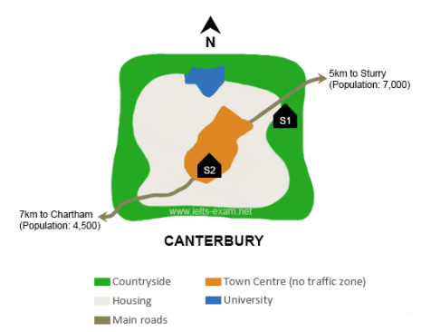
The map shows two potential places to build a new school in the town of Canterbury.
Overall, the main difference of two possible sites is that S1 is situated in the country side area, to the East of the town while S2 stands in the heart of Canterbury, within easy reach of housing zone.
The main road runs from the South West to the North East, which accesses directly to S1. By contrast, this road does not approach straightly to S2 because of no traffic zone here. It is 7km from S2 to Chartham, a town with a population of 4500. Beside, S1 is more convenient to approach by residents from a bigger town, Studdy, which is 5km from S1 along the main road.
The university is sited in the North of the town, which is bordered by both countryside and housing, having the same distances to two potential sites of new scholl.
Top answer
The map shows two potential places to build a new school in the town of Canterbury. Overall, the main difference between of two possible sites is that S1 is situated in the country side area , to the E ast of the town while S2 stands is in the heart of Canterbury, within easy reach of close to housing zone . S1 is on t he main road run ning from the South West southwest to the northeast North East , which accesses directly to (unnatural) S1.
- The map shows two potential places to build a new school in the town of Canterbury.
- Overall, the main difference between of two possible sites is that S1 is situated in the country side area , to the E ast of the town while S2 stands is in the heart of Canterbury, within easy reach of close to housing zone .
- S1 is on t he main road run ning from the South West southwest to the northeast North East , which accesses directly to (unnatural) S1.
- By contrast, S2 is not accessible by this road does not approach straightly to S2 (unnatural) because of the no traffic zone here .
- It is 7km from S2 to Chartham, a town with a population of 4500.
Get the Weekly English Kit 📬
New words, one handy idiom, and a 2-minute quiz — delivered to your inbox to keep your streak alive.
The map shows two potential places to build a new school in the town of Canterbury.
Overall, the main difference between of two possible sites is that S1 is situated in the country side area, to the East of the town while S2 s
 Related Questions