
Please review my IELTS essay.
The maps below show the changes that have taken place at the seaside resort of Templeton between 1990 and 2005.
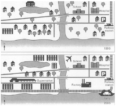
The two maps illustrates the transformation of the coastal resort of Templeton which occurred during a 15-year period from 1990 to 2005. In general, it is evident that the seashore vacation spot witnessed a spectacular modernization, including new buildings and facilities.
In the past, there used to be a few individual houses surrounded by green trees in the top right-hand corner of the resort; however, the next 15 years, several houses and trees were replaced by skyscrapers and apartments with only the lake remaining unchanged. Furthermore, on the opposite side, the school and hospital were still there as in 1905 but plants were cleared to make way for the construction of an airport and the building of more houses, which was what happened in the bottom right-hand corner of the area. Meanwhile, over the bridge, besides the unaffected house and park, residential houses were knocked down, resulting in an empty space.
Another developments took place in the northward direction with the erection of a supermarket. More tall buildings emerged here in place of separate houses and the trees were chopped down to give way to the factory on the left. Some notable developments also included the introduction of the third bridge near the mouth of the river, the appearance of a ferry next to the railway station and a new stretch of railway through new bridge.
Get the Weekly English Kit 📬
New words, one handy idiom, and a 2-minute quiz — delivered to your inbox to keep your streak alive.
 Related Questions