
Please help me with ielts writing task 1
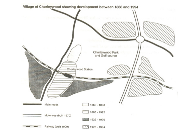
The map shows the change of the village called Chorleywood during the period from 1868 to 1994.
It is evident that the village developed as the transport system was improved. Four periods of growth are shown on the map, and each of the areas where people lived is near to the main roads, the motorway and the railway.
Between 1868 and 1883, Chorleywood included a small area next to a part of the main roads. Chorleywood Park and Golf Course is now located beside the earliest village area. The village grew along the main road to the south over a following period of nineteen years. Besides that, in 1909 a, a railway line was built crossing this area on the left to the right, with the station is in this part of village.
The extension of Chorleywood continued being close to the west and east side of the railway line till 1970. At that time, a motorway was built in the eastern part of the map, and from 1970 to 1994, further development on the village took place around the motorway intersections with the railway and one part of the main roads.
Thank you so much.
Top answer
The map shows the change s in of the village called Chorleywood during the period from 1868 to 1994. It is evident that the village developed as the transport system was improved. Four periods of growth are shown on the map, and each of the areas where people lived is near to the main roads, the motorway and the railway.
- The map shows the change s in of the village called Chorleywood during the period from 1868 to 1994.
- It is evident that the village developed as the transport system was improved.
- Four periods of growth are shown on the map, and each of the areas where people lived is near to the main roads, the motorway and the railway.
- Between 1868 and 1883, Chorleywood included a small area next to a part of the main roads.
- Chorleywood Park and Golf Course is now located beside the earliest village area.
Get the Weekly English Kit 📬
New words, one handy idiom, and a 2-minute quiz — delivered to your inbox to keep your streak alive.
The map shows the changes in of the village called Chorleywood during the period from 1868 to 1994.
It is evident that the village developed as the transport system was improved. Four periods of growth are shown on the map, and each of the areas where people lived is near to the main roads, the motorway and the railway.
Between 1868 and 1883, Chorleywood included
 Related Questions