
Please, help me review my map description
The maps illustrate how Sawry District looked in 1920 and 2020.
Overall, the district developed in terms of amenities.
Looking in more detail at the south of Sawry District, it was divided from the north by Oak Avenue, a street traversing it horizontally. This street remained unchanged. In 1920, there was a lake called Miller’s lake, to the north of which was Prestwich Primary School and to the east of which were trees. By 2020, the school had been replaced by Lonoco Petrol Station, and some trees had been cleared to make way for a bigger Prestwich. In 1920, moreover, there were two houses and a shop enclosed by a road; however, after the house in the southwest was knocked down, two apartment buildings, more houses and an additional shop were built.
The north had Tulebug Bros. Cannery factory, surrounded by trees, and although the trees were left untouched, Yang Office Complex had taken the place of the factory by 2020. In the northeast, a bike path replaced the beach, the road was lengthened northerly, two houses were destroyed, and an apartment building was erected. A bridge was added to the road, enabling unrestricted transport.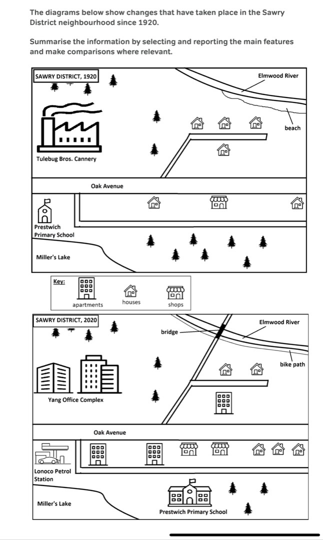
Top answer
The maps illustrate how Sawry District looked in 1920 and 2020. That is not a very good introduction. Overall, the district developed in terms of amenities .
- The maps illustrate how Sawry District looked in 1920 and 2020.
- That is not a very good introduction.
- Overall, the district developed in terms of amenities .
- (That is not a good word choice.
- The word is misused.
Get the Weekly English Kit 📬
New words, one handy idiom, and a 2-minute quiz — delivered to your inbox to keep your streak alive.
The maps illustrate how Sawry District looked in 1920 and 2020.
That is not a very good introduction.
Overall, the district developed in terms of amenities. (That is not a good word choice. The word is misused. The paragraph is too short. You should write about two or three main features, that is, the things that stand out.
Looking in m
 Related Questions