
Please help me by correcting my essay, many thanks!
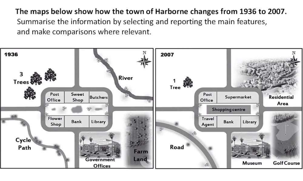
Two maps illustrate data on the changes of the town in Harborne between 1936 and 2007. The changes show the development of this region.
Overall, the big transformations concentrate primarily in eastern area. There are no changes about the separation of this area. Harborne is separated 5 part: 1 central part and remaining 4 regions around the central part between 1936 and 2007.
The north-western area in 1936 has 3 trees but there was only 1 tree in the year 2007, decreasing 2 trees. In the north-eastern region, there was a river and the rest were vacant land in 1936. Nevertheless, up to the year 2007, this area changed completely. The high buildings, the residential areas were constructed around the river.
The central region had some transformations. There were no changes for post office, bank and library. The flower shop was replaced with a travel agent in 2007. Sweet shop and butchers in 1936 were merged to supermarket in the year 2007. The central vacant land had a shopping centre in 2007. The south-western region had some of small changes. The cycle path in 1936 was reconstructed to a long road. The rest of vacant land was kept stable. In the south-eastern, the government offices in 1936 was converted to the museum in 2007. Similarly, the farm land was also transformed to golf Course from 1936 to 2007.
Top answer
The / These t wo maps illustrate data (wrong word. ) on (wrong word) the changes of the town in Harborne between 1936 and 2007. The changes show the development of this region.
- The / These t wo maps illustrate data (wrong word.
- ) on (wrong word) the changes of the town in Harborne between 1936 and 2007.
- The changes show the development of this region.
- Model paragraph: The two maps of the town of Harborne and its surroundings, one dated 1936 and the other 2007, illustrate all the changes that have been made over the six decades.
- Overall, the big (poor word choice.
Get the Weekly English Kit 📬
New words, one handy idiom, and a 2-minute quiz — delivered to your inbox to keep your streak alive.
The / These two maps illustrate data (wrong word. "Illustrate" means to make a picture.) on (wrong word) the changes of the town in Harborne between 1936 and 2007. The changes show the development of this region.
Model p
 Related Questions