
Please give me some feedback on my IELTS Writing Task 1. Thanks!
The maps below show the development of a small fishing village and its surrounding area into a large European tourist resort.
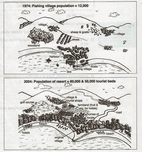
The two maps illustrate the significant changes of a tiny fishing village in Europe and its surroundings which have been developed for tourism over a 30-year period, from 1974 to 2004.
Overall, the modernization can be seen clearly with the introduction of many high-rise hotel blocks and permanent houses. Likewise, infrastructure and amenities increased, along with the resort’s capacity to cater to tourists.
In 1974, the fishing village had a population of around 12,000 and there were also two small villages in the mountainous areas nearby. To the northwest of the seaside village was woodland, adjacent to an olive forest. Besides fishing activities, the inhabitants also herded cattle such as sheep and goats.
However, the village had grown substantially by the year 2004. An enormous number of hotels and skyscrapers were erected along two beaches to accommodate about 80,000 inhabitants and 50,000 tourists. Additionally, the mountains had been linked to the residential areas by a new road. The establishments of facilities such as a golf course, tourist shops had resulted in the demolition of the woodland and olives had also been supplanted by fruits and vegetables in farmland. Meanwhile, the original village had remained unchanged, except for the construction of local homes.
Get the Weekly English Kit 📬
New words, one handy idiom, and a 2-minute quiz — delivered to your inbox to keep your streak alive.
 Related Questions