
PLEASE CHECK MY ESSAY
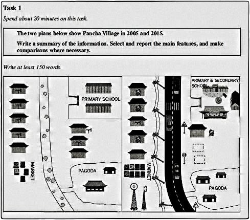
The two maps illustrate how Pancha Village changed between 2005 and 2015.
In general, the village became more developed and industrialized with the addition of educational institutions, religious sites, and improved transportation infrastructure and electricity generation.
After a decade, the most notable difference was the construction of a newly north-south wider concrete road at the expense of a small pathway. In 2005, the eastern area of the Pancha consisted of two parallel primary buildings to the north, some residential accommodation in the center, and two pagodas to the south. Furthermore, on the west side laid many houses and markets.
By 2015, regardless of position, there was a newly built secondary school and one more pagoda, whereas some eastern houses were dismantled. In contrast, the opposite site had more significant changes with the expansion of the market and the installation of pylons along the left side of the road. Moreover, two electricity generation station was located to the south. On the other hand, accommodations remained intact on the northern side.
Get the Weekly English Kit 📬
New words, one handy idiom, and a 2-minute quiz — delivered to your inbox to keep your streak alive.
 Related Questions