
Map Task 1-Please check
The maps below show the centre of a small town called Islip as it is now, and plans for its development.
Summarize the information by selecting and reporting the main features, and make comparisons where relevant.
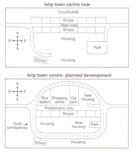
The maps illustrate the layouts of a small town named Islip before and after a proposed development.
Overall, the main changes include the construction of a divided highway around the center of the town with some new housing facilities.
As it is now, the Islip town is attached to the countryside northwards. Also, the main road connects the west of the town to the right. Alongside either of this road lays a row of shops. However, in the development, the main road is going to be pedestrianized and the northern shops will be demolished to make way for some facilities, from west to east: a bus station, a shopping mall, a car park, and a new housing connected to the divided highway by a road.
Below the planned pedestrian path will remain the current shops, but a new housing and a park will be added. All of these facilities and constructions in the new layout are bound to be surrounded by a divided highway that not only keep the vehicle track to the west and east of the town, but it also makes it possible to get to almost all of the places within the town. Finally, the school located on the north end of the town will be marginally bigger but the housing are next to its right will be untouched.
Get the Weekly English Kit 📬
New words, one handy idiom, and a 2-minute quiz — delivered to your inbox to keep your streak alive.
 Related Questions