
Ielts Writing Task 1 - Map
If it's really hard to see the image clearly, you can check from IELTS Cambridge 13 book.
My answer:
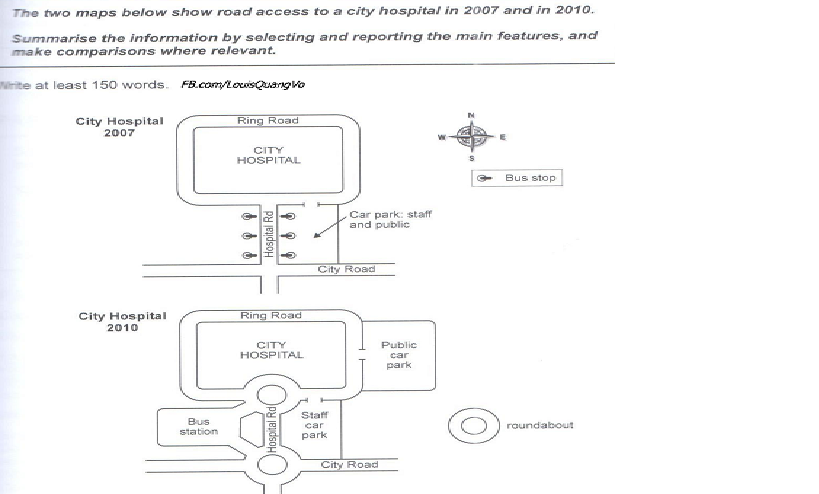
The diagrams illustrate the developments of transport infrastructures access to a city hospital between 2007 and 2010.
It is clear that some areas around the hospital have changed considerably with more convenient facilities. Overall, the new constructions make accessibility to the hospital become easier.
Looking at the maps in more detail, we can see that a new car park for all people was built in 2010 next to the hospital from the east. The old car park in front of the hospital has been only used for medical staff since 2010 instead of general use in 2007. Bus stops along the Hospital road were removed and replaced by a bus station located in the southwest of the City Road.
As well as the constructions mentioned above, the roads leading to the hospital has also changed. It is visual that two roundabouts were set off in the Hospital Road at the conjunction with Ring Road and City Road. However, the Ring Road around the Hospital remained.
---------------------------------
Thank you so much in advance if anyone help to recognize my mistakes.
Top answer
You must be very very careful to report the details accurately. The maps do not tell us what happened in 2008 or 2009. It only shows what existed at two different points in time.
- You must be very very careful to report the details accurately.
- The maps do not tell us what happened in 2008 or 2009.
- It only shows what existed at two different points in time.
- The diagrams illustrate the developments of transport infrastructures access (This is not good English) to a city hospital between 2007 and 2010.
- It is clear that (That states your opinion.
Get the Weekly English Kit 📬
New words, one handy idiom, and a 2-minute quiz — delivered to your inbox to keep your streak alive.
You must be very very careful to report the details accurately. The maps do not tell us what happened in 2008 or 2009. It only shows what existed at two different points in time.
The diagrams illustrate the developments of transport infrastructures access (This is not good English) to a city hospital between 2007 and 2010.
 Related Questions