
IELTS Writing Task 1
The diagrams below show the coastal village of Seaville in 1980 and 2010. Summarize the information by selecting and reporting the main features and make comparisons where relevant. Write at least 150 words.
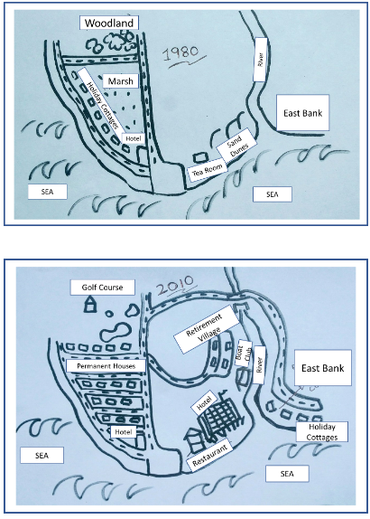
The pictures describe the development of a seaside residential area of Seaville in 30 years, from 1980 to 2010. It's clear that the village had had some significant changes for the mentioned period from a plain land with a few human influences to a tourist spot with many modern improvements.
For tourism, instead of Tea Rooms and Sand Dunes, after the reform it was turned into Restaurant and Hotel. There also had been some changes to the riverbanks, a Boat Club in the West Bank replaced for the plain land in 1980. Moreover, WoodLand was no longer a forest yet became a Golf Course in 2010.
For the vital infrastructure, due to the addition of Permanent Houses in 2010, the Holiday Cottages had to move to the East Banks followed by the disappearance of the Marsh. In the middle of the map, a Retirement Village had been built in a place which was blank in 1980. Owing to the expansion of residential areas, roads had been made in order to travel around the place.
Top answer
Please read my advice for Task 1 essays. IELTS TASK 1: Hints, Tips And Advice Vocabulary Words For Task 1: Reference Post For task 1 with before/after maps, I recommend the following structure: Outline: Paragraph 1: Introduction - Describe the maps. How many are there?
- Please read my advice for Task 1 essays.
- IELTS TASK 1: Hints, Tips And Advice Vocabulary Words For Task 1: Reference Post For task 1 with before/after maps, I recommend the following structure: Outline: Paragraph 1: Introduction - Describe the maps.
- How many are there?
- Paragraph 2: Overview - Report the main features.
- Paragraph 3/4: Comparisons For before-after maps I recommend one paragraph for "before" and another with the differences..
Get the Weekly English Kit 📬
New words, one handy idiom, and a 2-minute quiz — delivered to your inbox to keep your streak alive.
The pictures two map sketches describe (not a good word choice.) the development of a seaside residential area (Incorrect. You will not find hotels and businesses in a residential area.) of Seaville
 Related Questions