
IELTS Writing Task 1
The maps indicate the current appearance of the central point of a town called Islip, and new developmental design planned for it.
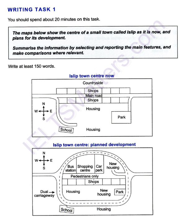
The shops in the center of Islip are crossed by main road right in the middle. This road reaches the school through a dead-ended street which heads south before the southern line of shops. On the southeastern side of the road there is a short street that goes to a park. The park can be seen from the housing that is located behind the southern line of the shops in two opposite locations.
However, on the planned map of the Islip's center main road is planned to change to a dual carriageway circling the whole central area with the expanded school and a section of the housing outside the southern edge of it. The Northern line of shops are changed into bus station, shopping center, car park and new housing. The former place of the main way is meant to be used by pedestrians only. In addition, another new housing is planned to be built in the Western side of the park.
Overall, it is clear that the majority of the buildings in the central part of Islip are planned to be expanded or be used for different purposes. In addition, a number of new buildings and roads are meant to be built.
WRITE DESCRIPTION HERE
Top answer
The maps indicate the current appearance of illustrate how the central area point of a town called Islip looks now , and its appearance subsequent to new planned future developmen t. al design planned for it. The two rows of shops in the center of Islip are currently crossed separated by the main road right in the middle.
- The maps indicate the current appearance of illustrate how the central area point of a town called Islip looks now , and its appearance subsequent to new planned future developmen t.
- al design planned for it.
- The two rows of shops in the center of Islip are currently crossed separated by the main road right in the middle.
- This road reaches the schoo l, which is in the southwestern part of town, through a dead-ended branch of the main road.
- street which heads south before the southern line of shops.
Get the Weekly English Kit 📬
New words, one handy idiom, and a 2-minute quiz — delivered to your inbox to keep your streak alive.
The maps indicate the current appearance of illustrate how the central area point of a town called Islip looks now, and its appearance subsequent to new planne
Atalantacentral point
This is strange and unfamiliar in British English. You could write the centre of a town called Islip.
 Related Questions