
I really hope you check my Maps exercise. Thanks a lot.
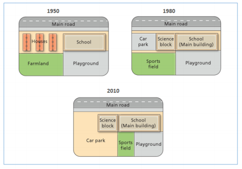
The diagrams below show the changes that have taken place at West Park Secondary School since its construction in 1950.
Summarise the information by selecting and reporting the main features and make comparison where relevant.
The three maps give information about West Park Secondary School’s changes through three specific years 1950, 1980 and 2010.
Overall, the most dramatical change belonged to car park, which had not existed in 1950 until 1980 and then in 2010, was expanded to attain the largest area. By contrast, there were farmland and houses in 1980 but in the next 30 year there were not.
In 1950, the school was located to the south of the main road which then called main building as a result of the construction of a new science block. There were many houses located in the northwest in 1950 but in 1980, they were destructed to give way to car park and science block. Similarly, the farmland in the Southwest area was demolished and replaced by a sports field. The playground in the Southeast, however, stayed unchanged.
From 1980 to 2010, there was no change with science block and school. However, car park enlarged significantly to the South, resulted in the narrowing of sports field and playground.
Get the Weekly English Kit 📬
New words, one handy idiom, and a 2-minute quiz — delivered to your inbox to keep your streak alive.
 Related Questions