
I need to check it, Please help me ! (This is the essay of the IELTS Writing - Task 1)
The diagrams show the different area of West Park Secondary School and neighborhood that include: Main road, School, Houses, Farmland, Playground, Science block, Car park and Sports field. Additionally, the pictures also show the changes in this area in the different three years: 1950, 1980, 2010.
In 1950, the behind of the Main school is a Playground, the west of the school is Houses, the southwestern corner of it is a Farmland. In 1980, the houses were replaced by Science block and Car park. While, the Farmland was replaced by a Sport field, the Main school and Playground had not the changes. In 2010, the Car park was expanded to the area of the Sport field, while one part of the Playground area was a new Sports field, the Science block was not changed.
There was not change of the Main school in the different three years. While the Farmland was removed and the Sports field and Playground were shrinking, the Car park was expanded as time goes by.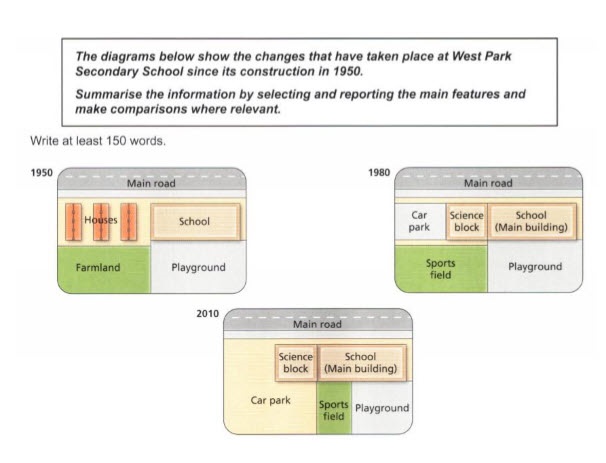
Top answer
Please post essays in the essay forum so a moderator does not have to move your post. htm
- Please post essays in the essay forum so a moderator does not have to move your post.
- htm
Get the Weekly English Kit 📬
New words, one handy idiom, and a 2-minute quiz — delivered to your inbox to keep your streak alive.
Please post essays in the essay forum so a moderator does not have to move your post.
https://www.englishforums.com/English/EssayReportCompositionWriting/Forum9.htm
The diagrams show the different area (not a good phrase) of West Park Secondary School and neighborhood that include: Main road, School, Houses, Farmland, Playground, Science block, Car park and Sports field. Additionally, the pictures (You wrote "diagram" first. Don't give two different wor
 Related Questions