
Development of Chorleywood; IELTS Task 1
Chorleywood is a village near London whose population has increased
steadily since the middle of the nineteenth century. The map below shows
the development of the village.
Write a report for a university lecturer describing the development of the
village.
You should write at least 150 words.
My Essay:
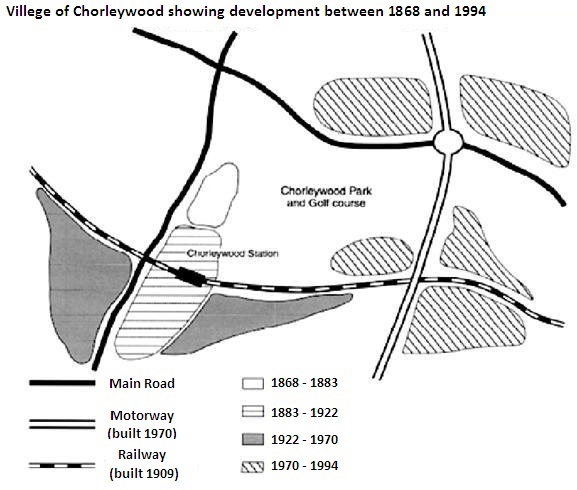
The given map highlights the development of, a village near London, keeping a track of its expansion since 1986 and comparing its area and communication access over four distinct periods.
At first glance, it looks like the area of Chorleywood has increased tremendously over the given 126 years time and eight new colonies can be identified in 1994, spreading along the main roads, Motorway, and Railway station.
In 1868 Chorleywood was a small village just across the right of the vertical main road, but after fifteen years, it expanded parallel to the same main road, where a Railway station was built later in 1909. It was the only development for the next 39 years. Then two new localities were built parallel to the railway line but separated by the second development and the main road. For the next forty-eight years, Chorleywood consisted of these four discrete locales until the introduction of Motorway in 1970, when five new pockets emerged over the next 24 years. Two of these new communities were situated at the intersection of Motorway and the horizontal Main road; one on either side of the Motorway. The other three surfaced on the area where Motorway was crossing the Railway line.
Top answer
) and comparing its area and communication (wrong word. There are no telegraph/telephone lines or cell phone towers on the map) access over four time distinct periods. (What are the time periods?
- ) and comparing its area and communication (wrong word.
- There are no telegraph/telephone lines or cell phone towers on the map) access over four time distinct periods.
- (What are the time periods?
- ) At first glance, it looks like T he size area of Chorleywood has increased tremendously (How much?
- ) over the given 126 years time (1986 to the present year is not 126 years.
Get the Weekly English Kit 📬
New words, one handy idiom, and a 2-minute quiz — delivered to your inbox to keep your streak alive.
The given map highlights the development of, (never put a comma between a preposition and its object) a village (What is the name of this village?) near London, keeping a track of (wrong phrasing) tracking its expansion since
 Related Questions