
Could you please review my ielts writing task 1 essay
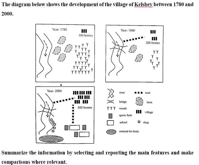
The pictures illustrate how Kelsbey village developed from 1780 to 2000.
Overall, there were significant changes that had been made in terms of infrastructure, public amenities and housing. Remarkably, the number of households in Kelsbey village increased drastically, whereas farms disappeared gradually over the period shown.
In 1780, there were 100 households located in the north-east of the village and 4 big farms in the center. At this time, Kelsbey village had a vast amount of woods in the east and a river running from north to south in the west side. In 1860, there were a considerable increase in the number of households, to 200 homes. However, the amount of woods and the number of farmlands reduced by half. In the same year, a bridge across the river and the road connecting the river to the residential area were constructed. In 2000, the residential area was double in the number of households, but all the farmlands and woods were removed completely from the map of Kelsbey village. On the other hand, several schools and sport fields were built at the south-eastern corner of the village, and they were linked with the residential area in the north by a new road. In addition, there were some new shop along side of the river in the south and a wetland for birds at the end of the river.
Top answer
The map is not a fixed feature of the geographical area. It is the choice of the map maker. Think of the map as a window.
- The map is not a fixed feature of the geographical area.
- It is the choice of the map maker.
- Think of the map as a window.
- You are describing what is outside the window - the features with respect to each other, not the window itself.
- The pictures illustrate how Kelsbey village developed from 1780 to 2000.
Get the Weekly English Kit 📬
New words, one handy idiom, and a 2-minute quiz — delivered to your inbox to keep your streak alive.
The map is not a fixed feature of the geographical area. It is the choice of the map maker. Think of the map as a window. You are describing what is outside the window - the features with respect to each other, not the window itself.
The pictures illustrate how Kelsbey village developed from 1780 to 2000.
Overall, there were significant changes that had been made in
 Related Questions