
Chorleywood is a village near London whose population has increased steadily since the middle of the nineteenth century. The map shows the development of the village. Write a report for a university lecturer describing the development of the village.
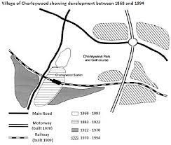
The map shows the development that took place in a village between 1868 and 1994.
Overall, the Chorleywood underwent a dynamic change in the transportation system and the portion of lands cultivated, the most significant of which are the expansions to the South and East sides of the village over the period given.
In the first 15-year period, the village constituted a small acre of land near the center of the map and two main roads in the Nothern and Western side of the map. From 1883 to 1922, the village opened a strip of land to the bottom left-hand side while a railway was completely constructed in 1909.
The town was extended by two areas of land in the next 48-year period, whereas no additional roadway was installed. During 1970 and 1994, a motorway was established along the Eastern side of the map, crossing both the top main road and the railway system. This functiones as the ground for its government to reclaim the greenfields located along the East of the town. 
Top answer
Please post essays in the essay forum so a moderator does not have to move your post. htm The images you attached are too small. They are very difficult to read.
- Please post essays in the essay forum so a moderator does not have to move your post.
- htm The images you attached are too small.
- They are very difficult to read.
- The print is too small and fuzzy.
- Use larger, clear images.
Get the Weekly English Kit 📬
New words, one handy idiom, and a 2-minute quiz — delivered to your inbox to keep your streak alive.
Please post essays in the essay forum so a moderator does not have to move your post.
https://www.englishforums.com/English/EssayReportCompositionWriting/Forum9.htm
The images you attached are too small. They are very difficult to read. The pri
The map shows the development that took place in a village (What is the name?) between 1868 and 1994.
Overall, the (wrong usage) Chorleywood underwent a dynamic change in the transportation system and the portion of lands
 Related Questions